Day Two
8-31-04
Rising early we were quickly packed and ready for the road.
Our first stop was easy to find. Besides the established stations there were many “unscheduled” stops which were as routine as any other but not listed on the time table. The first of these south of Springfield was the “Ray House.” At N37 º 6.4' and W93 º 23.8' It is now located just within the eastern boundary of the Wilson Creek Battlefield National Park. Also known as the Wilson Creek Post Office, it was owned by Mr. John Ray and would later become famous as the house to which General Nathaniel Lyon was taken mortally wounded during the Battle of Wilson’s Creek. The battle fought here on August 10, 1861, was the first major Civil War engagement west of the Mississippi River, involving about 5,400 Union troops and 12,000 Confederates. At the time of the Butterfield, however 
Here's a great picture of the Ray house. 1882-84.
Photo courtesy Dr. Tom Sweeney.

For a map of the Park showing the Butterfield trail through here, Click Here.
From here the trail crossed southwest through the park and headed towards Double Springs and thence to the Ashmore Station.
After spending a brief time in the park and finding a long sought after book called, “Down the Old Wire Road” by Fern Angus, we hit the road and dog-legged toward Clever, Missouri. We missed seeing the sign for Ashmore’s Station as we road down the secondary road but later Paul was able to find it on a weekend research trip.
The trail did not exactly follow the current roads but this marker is located at N37° 4.013' W93° 25.805' and probably represents where the trail crossed this existing road. Heading on toward Clever, there are remnants of the Old Wire Road that are marked and which often followed the Butterfield route. The Wire Road refers to construction of the first telegraph line which took advantage of the existing roads and was installed in this area around 1859. It became a major element during the Civil war as both sides sought to control and utilize the road to efficiently move troops. As a result there are many Civil War battle sites referenced along the way. Just west of Clever is one of these battle sites known as Dug Spring. Dug Spring is still visible and is
These sites were quite useful in trying to determine the general route of the Butterfield. Passing the Old Curran Post Office run by Robert Teague and Old Christoe church the trail left Christian County and entered Stone County near the Steele Cemetery which is located at N36° 59.303' W93° 31.496' and named for a prominent family. The William Steele home was located southwest of the cemetery and the Wire Road is said to have run on the west side of the home and cemetery.
There was a very good reason why there was a change of coaches at the Springfield Station. As the Butterfield left Springfield the roads went from bad to impossible. Some of the most rugged terrain anywhere along the route would be encountered between Springfield and Fort Smith, AR. “To accommodate the challenging conditions the OMC utilized a variant of the Concord coach called the celerity coach, more often called a "mud wagon." This was either a lighter, smaller, simpler version of the Concord, or, more often, a 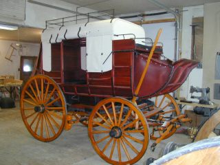 wagonette. A square-bodied, homely conveyance with a top of treated canvas stretched over wooden struts, it lacked the Concord's beautifully curved and joined panels, being enclosed only halfway up by flat panels decorated with a roving of wood strips to make it look more expensively made. Its carriage and running gear were lighter than the Concord's, but still sturdy enough for slower travel over muddy roads, and it had the same sort of thoroughbraces as the big one. When its canvas side-curtains were rolled up and fastened, it was almost completely open, which let in more dust but also admitted every available breeze. Built like its big brother by Abbott & Downing, it was tough and durable, but lighter in weight, and had a lower center of gravity, making it good for mountain roads. The body measured from 6'10" to over 8' high, the track 5'2" and it weighed from 800 lb. (for the commonest nine-passenger model) to 1200 (for a 14-). It had two to three inside seats (no roof passengers), and baggage was stored in the single rear boot or piled inside with the passengers. It was much in favor during rainy spells: sometimes a heavy Concord got mired down, but six horses (or more often mules) could pull a mud wagon through just about anything.”2 The road south was said to be little more than a “lane of tree stumps” winding through the timber and careening into the steep hollows of the Ozark Mountains. The next scheduled stop was Smith’s Station however, a well known unscheduled stop was down into one such hollow.
Called McCullah Hollow after Alexander McCullah family. Located one mile west of Brown Spring the site of the small village cannot be reached by road today, however, portions of Butterfield are still marked on the secondary roads that dog-leg towards Osa, Missouri. I know that one can drive within sight of the homestead and I believe on an earlier mission I had seen what I thought was the McCullah valley so I need to investigate a bit more. Passing north of Crane, Missouri and through Oak Grove we went into the Wire Road Wildlife Management area and towards Osa. We took a combination of back roads and blacktop towards Smith’s Station.
At one confusing crossroads we stopped to consider the map. Out of nowhere came one of those mysterious strangers destined to guide us through the shrouded mists of time. This gentleman, dressed in Bermuda shorts and attached to no visible nearby structure, was so incongruous to the dusty gravel road we found him on that talking to him was the only reasonable course of action. We introduced ourselves and defined our quest. “Well”, he said, “You can go that way”, pointing down a gravel road, “but I know the place your looking for and it would be much easier to take the highway around and come in from the other side.” We thanked him and asked some clarifying questions about the route. Later, we both agreed that it was how he just came walking up, out of nowhere, that really seemed so odd.
Smith’s Station was really magical. The station master was John I. Smith and operated Smith’s Tavern or Inn and the present site is well preserved and marked. It is, however, somewhat inaccessible and a bit off the beaten path. 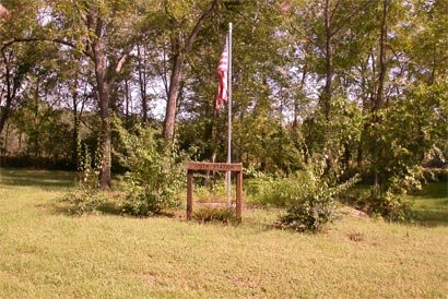 That’s one of things that make it so satisfying. There is a home there and we felt mildly intrusive but it is clear that the owners of the property are well aware of the special significance of the place. It is marked with a Centennial Marker and an American flag. It is located adjacent to Wise Spring, N36° 53.687' W93° 40.45' which is beautiful and quiet and the spring gives an obvious reason for the choice of this spot as a station. We lingered here and took some pictures. It was perhaps one of the most beautiful and restful spots we encountered. Its isolation and its verdant tranquility spoke of a rest well deserved for a traveler from any time..
From Smith’s we continued southwest through Madry, (site of another Civil War battle in 1864). We wound around Flat creek, though the Butterfield was said to follow it, but we went through Mcdowell as did the Butterfield.
In stretches like this you could really feel the history. The seldom traveled roads were empty of traffic and lined with the most nostalgic remnants of the past. Sometimes this would be juxtaposed with reminders of the too frenetic concerns of the present day. Directly across from where the next photo was taken was a house with half a dozen junk cars and the butt end of a styrofoam deer target standing in the front yard. I will leave that to your imagination.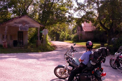
It was at this crossroads that Paul and I made a decision to split up for a time. I had been through here before and wanted to follow the roads that led like the Butterfield down “Flat Creek” into Cassville. Paul opted to take the blacktop west to highway 37 and then south. We agreed to meet in Cassville. I was in search of Crouch’s Station. I had missed it before in earlier trips and thought this time with a little luck I could find it. I knew now that there was a Centennial marker and felt that was the element that might make the difference.
A few miles down the road and Paul’s decision seemed to have been validated. I met a road grater and the road behind him was newly tilled into a fine loose slurry of gravel. Fortunately, he had stopped and I pulled over to ask him about the road and seek his council. He was a prince among county road crews. He explained that he hadn’t been working long and soon the road would turn better. Further, he was familiar with my intended destination and gave me a pointer on what to look for.
So, down the hill and across Gunter Creek I went around Bright Springs Knoll and paralleled Flat Creek. Just past Star City I was cautioned to stay left and not continue on U road. Luckily, I didn't miss the turn and then passed a family working a field just beyond a farm house. They told me to look for the marker at the end of the field. There is no way I would have seen it without their help. The marker for Crouch’s Station is at N36° 44.900' W93° 49.100'.
The marker was in some bushes and had come loose from its concrete base. I didn’t have a camera with me, but it was of the same Centennial type we had found at the other stations.
Continuing on into Cassville following Flat Creek I drove passed cemeteries and right onto Main St. There is always a feeling that you are on the right track if you end up on a historic Main street. I found Paul gassing up at the first gas station I came to. Which was lucky since we hadn’t really arranged a spot to meet.
In Cassville we picked up Highway 37 and continued south. Paul had told me about a woman he had met south of Cassville who claimed to live at one of the old stagecoach stations. The next official station was at Washburn but we had already come to expect that any good water source or historically significant establishment was a possible unscheduled stop. This woman claimed that when she and her husband had added an addition to their house they had discovered an old well and that it was said to be part of an old stage stop. We found the farm right off the highway. She was gracious and invited us into her home to show us the well which had been converted to a glass topped coffee table.
It was truly amazing and was lit from inside with flood lights and the water shown up from the depths below.
One of the things that sticks in my mind was that she also had full sized matched set museum reproductions of the sarcophagus of King Tut in her family room too. I’m not really sure what that means.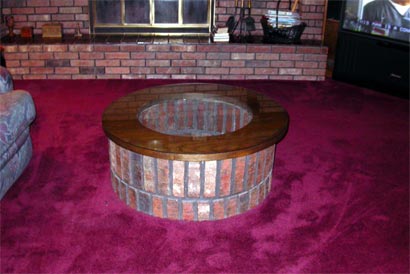 It seems like it would be remiss to leave it out though. Following you will see a picture of the glass topped coffee table. Without a picture I wouldn’t believe it either.
Traveling south on highway 37 we were anticipating Washburn, Missouri.
Somewhere near here was the next station, Harbin’s Station.
Click here for a Harbin Station update June 2009

John G. (H.?) Harbin, Station Master. We picked up the Old Wire Road just south of Washburn as 37. Looking for and finding 1050 (Rock Creek road) . It is rough road. Just as you exit the highway onto 1050 there is a large collection of rocks held together by old wagon wheel rims. The Station’s exact location is still not known but this is just about one mile south of Washburn and six miles north of the Arkansas line, exactly as described by the timetable.
The road descends into Washburn Hollow and a more harrowing rutted rider-throwing road does not exist. In a word it was, perfect. This stretch of road is so authentic and clearly marked as Old Wire Road that one slips effortlessly through the veil of time.
Somewhere just passed the Missouri/Arkansas line we dropped into a valley and followed a one-lane dusty road between barns and sheds so close to the road that we wondered at times if we had lost the road and wandered onto private property. Rounding a sharp bend we entered an old homestead replete with a flagstone house and an old red barn from the right period and just across the way we saw this: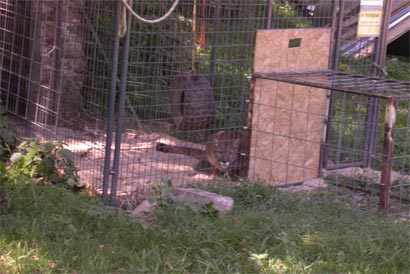
Yes, that is a mountain lion. Someone’s idea of a good yard pet. Fortunately, since that time Arkansas has passed a law making it illegal to keep these animals without a permit. Still, it just sort of reminded us that we were certainly hanging out at the edge of civilized behavior.
The next “unscheduled” stop was at the famous Elkhorn Tavern. The routewent through a fence at the edge of the Pea Ridge National Military Park so we cut out to the highway and went around to the entrance.
Pea Ridge is another famous Civil War battle site. Once again the Old Wire Road acted as an agent of transport and funneled the Confederate
and Union soldiers to a bloody and decisive confrontation. Paul and I, though respectful of the magnitude of these battles, were focused on the task of our journey and so at this time gave them a honored pause but moved on to our primary objective, the Butterfield.
The Elkhorn Tavern N36° 27.220' W94° 0.946' was constructed in 1833, three years before Arkansas became a state and two decades before the first Butterfield stagecoach stopped to give its weary passengers a chance for a cool drink and perhaps a bite to eat. It was first built by William Reddick (or perhaps Ruddick). How long he and his son-in-law Samuel Burks lived in the first log construction is not known but it is known that by October of 1858, just after the first Butterfield runs it was sold to Jesse C. Cox. It remained in the Cox family until it was sold to the State of Arkansas in 1959. In 1960 it became part of the Pea Ridge National Military Park. It went through many permutations in its long history b ut stands now looking very much the same as it did in 1858. Due to exhaustive research and an extensive restoration effort it was reconstructed between 1965 and 1967. Originally, it was constructed not as a tavern but as a home. As a center of community however, it also found its uses as a trading post, a post office, place of worship, and eventually as an inn and tavern. The Old Post Road or Fayettville/Springfield Road came right by its front door and with it brought both opportunity and unfortunately disaster.
Though burned to the ground by bushwackers shortly after the historic battle it was quickly rebuilt and continued as a major community focus.
Rogers, Arkansas was not incorporated until 1881 but the next scheduled stop, Callahan’s Tavern was said to have been located in what is now Rogers. Paul and I went first to the Historical Museum down in the heart of town. There we were well met and guided to some of their research materials. They have there a photocopy of an out of print book that chronicles an adventure almost as amazing as the Butterfield itself.
In the late 1930’s there was a couple whose interests and zeal for uncovering the story of the Butterfield Overland Mail drove them into a life long obsession. Roscoe and Margaret Conkling embarked on a life time of study and drove almost the entire route in their 1930 Buick and published three volumes of their research. T o think of this couple, consumed with curiosity and driven, literally, to seek out every remnant of the Butterfield that remained into their day, gives one pause. Their work laid the foundation for all those who followed and to find a copy was quite extraordinary. I noted once in my research on the internet that one could buy a copy for $600 if one was lucky enough to be invited to the sale.
Paul and I were not in a prolonged research mode and I agreed that we should keep our focus for the day more specifically on finding the next stop, Callahan’s.
Fortunately, the Assistant Director of the museum gave us excellent directions. She cautioned that there was little that remained. Back on the streets we wound our way into an older residential section east of the Wire Road and adjacent to Highway 12. There at the dead end of Spruce St. we began to wonder where to go next.
This was not the kind of neighborhood where we could leave the bikes unattended and it seemed like there couldn’t be anything left of the station but I remembered Allyn at the museum had said, “I think there is a spring there or something.” There was an older strong looking brick antebellum house that had been converted to some kind of women’s center and that seemed sort of encouraging. Just when it began to seem prudent to leave I remembered thinking that sometimes waiting and doing nothing is the best plan. Sure enough, a moment later a small pickup came down the road and pulled into a nearby house. I convinced Paul to wait and approached the young man. After I explained what we were looking for, I asked about an empty house we had seen at the end of the road and wondered if he thought they would mind if I went down and talked to them. He picked up his groceries and said, “You know I don’t think there is anyone there. The cops were here last night knocking on their door and nobody seemed to be around.” He continued, “There ain’t much down there except an old shed and a spring box, anyway.” I thanked him, excited to report to Paul the news. He was less enthusiastic than I but he agreed to watch the bikes while I took the camera and headed off over the hill and out of sight.
The house looked like Methamphetamine Central. Tacked to the front porch was a big sign that said, “Beware of Dog.” I yelled a big "Hallllow" and approached. No answer. I went around the back and the scene just grew more threatening. The windows were busted out and beyond a garbage strewn back porch the door hung half off its hinges and partially open. No dogs yet, so I continued.
Below the house which was maybe 1950’s I saw what I was looking for, an old out building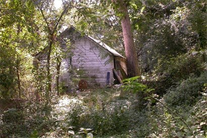 and some smaller structures. Sure enough, it was a spring box. The Spring box is not visible in this picture but is to the right of the
Callahan’s Tavern must have been a welcome sight in the remote isolation of this area. Later, I found this photo of Callahan’s Station on the web. It looks suspiciously like the Women’s Center that is on Spruce Street just above this area.
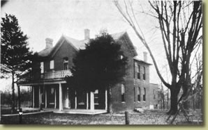 I don’t know if this means that the Women’s Center is the old Tavern or if someone has just mistaken it. I would have thought the museum director would have known if they were one and the same. Perhaps more research is needed, but I felt we were within a hundred yards when I noted these coordinates on the GPS, N36° 20.532' W94° 06.574'
When I got back to the bikes I could see Paul was relieved to be moving on and we headed out of town back through the Historic District and south on the Old Wire Road towards Springdale, Arkansas.
Along the way we passed through Cross Hollow N36° 16.687' W94° 6.837' another vicinity in which a major Civil War battle was fought and it is marked with a Historical marker and a reference to the Butterfield. Continuing on down the Old Wire road we went through an area referred to as “Mud Town.”
Mudtown N36° 15.386' W94° 7.056' is interesting not only because it helps to define the location of the Butterfield but because it illustrates the transient nature of towns and the elements they depend on for sustaining their vitality. Mudtown was known originally as Bloomington As the story goes, a driver for the Overland Butterfield Stage Line has been refreshing himself at a tavern in this wayside spot called Bloomington. When the driver and passengers returned to the stagecoach, they found the wheels had sunk up to the coach bed in sticky mud. In obvious desperation, the driver renamed the place "Mudtown".
Bloomington's first post office was established in 1858, but it came long after the first settlers.
The fate of Bloomington, "Mudtown", was sealed with the completion of the railroad line one mile west of town in 1881. The residents were considering moving their small town when a tornado blew in and settled the question. Several homes and buildings were destroyed. Most of the remaining buildings were moved west and Bloomington, "Mudtown", changed its name to Lowell.
Many small towns like Bloomington owed their success to the fact that they were on a thoroughfare and it was the passing of commerce through the town that sustained it. As the railroad moved west many towns were founded along the rails. Existing towns courted the railroad companies and lobbied hard to be included on their routes. Bloomington is a rare example of a town that having missed this opportunity literally moved itself to the railway instead. In much the same way most small towns now exit far from the commerce of interstate highways their dusty Main Streets vacantly facing an absent railway. Without the steady flow of transportation the life blood of the community is diminished and the town finds itself slowly nodding into sleep. Some disappear completely into the dream of history and some do hold on long enough that their historic charm invites a renewal.
Like the travelers of old we were approaching one of our prime destination, Fayetteville, Arkansas. The terminus of one of the most significant roads in the history of the Ozark mountains. The land for the Springfield-Fayetteville road was surveyed in 1835 by A.A. Jamison, but it followed the Ozark Indian trail whose origins wind back into time beyond the telling. On this day though we were just as anxious to first find the next station on the outskirts of Springdale, Arkansas. I had already located the Fitzgerald Station before this day but looked forward to showing Paul this magnificently preserved stable and somehow approaching it from along the trail turned my next meeting into magic.
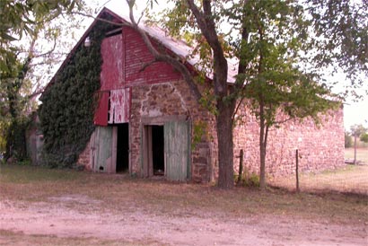
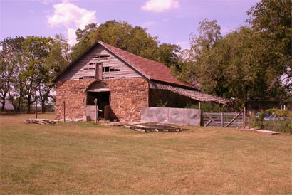
The Fitzgerald Station is a fine old stone barn and one of the only Butterfield liveries that still stands.
It is located at N36° 12.805' W94° 6.804'. The reason I held this place special as well, was because it was on a one of those busy roads named Butterfield that I had passed often in my journeys to and from my nearby home. It was one of the first roads I encountered that just begged to have questions answered. Out west, I understood why they named things Stagecoach this or Butterfield that. But why Springdale, Arkansas? For me Springdale was a smallish backwater city that happened to have the first Sam’s club in the area and once a month I went shopping there. And once a month, at least, I crossed this road and would think, “Why here?”
As I began my research and realized the major jewels in this beaded necklace of stations I was thrilled to find out that one of the stations was in Springdale though at the time of the Butterfield it was called Shiloh. I was even more thrilled when it was suggested that the building still stood. So one day on one of my Sam’s trips I took some time and began looking. I was successful after a fashion and duly rewarded by the size and quality of the structure.
 On this day Paul and I pulled off the highway and into a small parking area to find that since my last visit the place had been put on the National Register of Historic Places and a new sign had been erected. The owners had been busy cleaning away years of accumulated machinery and debris and the place was even more impressive. That day I remember we were greeted by a red-tailed hawk in the tree above the barn. He called to us and then flew to a nearby perch watching with interest as we took pictures.
 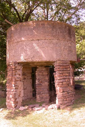 There was an old well and this interesting water tower.
There is also what looks like a turn of the century house nearby but no author mentions it as connected with the Fitzgerald Station. In 1858 the passengers often spent the night in town at the one of the few hotels in the Ozarks at the time. The Gladden Hotel offered rest and a good meal to the traveler that wish to stay the night and take the next stage through. It no longer stands but I am sure I can get a picture of it.
Unlike those passengers, we didn’t linger long. We had set our sights on Fayetteville, which was only thirty minutes away and were planning on spending the night there.
Fayetteville is another one of those places that I visit frequently and so was familiar with but familiar in that way we often are with a place. I knew where the Cineplex was and the good Thai restaurant and had been to the Performing Arts Center to see fabulous performances by well known artists many times. For twenty-five years I had been a casual visitor without really connecting with the soul of the place. Now, as we wound our way through familiar streets they looked somehow newly washed in meaning.
A half block down from my favorite restaurant was the site of the Fayetteville Station. N36° 03758 W94° 29.508' We pulled in and unfortunately the restaurant was closed and once again the day was fading fast. For some reason we did not get a picture of the historic Old Courthouse that stands on the site now, but I went back later and got this one. Butterfield maintained a station there and it was run by one of his sons and later Butterfield built a hotel in town which was run by his wife and eldest son. 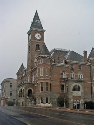
John Butterfield had a special love for Fayetteville. He considered the region to be “the most beautiful and healthful along the route. He bought 360 acres of land on the west side of town and often entertained his eastern friends here and hoped to retire eventually to the area. Sadly, this was not to be.
John Butterfield was 57 years of age at the time of this enterprise. Ormsby, seems continually impressed by what he describes as, “the most energetic president of a company I ever saw.” He continues, “He appears to know every foot of ground and to be known by everybody.”
Paul wanted to stay at the Best Western on the edge of town so we drove south to be ready for the next days ride. Ormsby describes Fayetteville this way, “This town is located up among the hills, in a most inaccessible spot, in Franklin County,(should be Washington), said by its inhabitants to be the star county in the state. It has two churches, the county court house, a number of fine stores and dwellings, and, I believe, about 1,800 inhabitants. It is a flourishing little town, and its deficiency of a good hotel will, I understand be supplied by Mr. Butterfield, who has bought some property for that purpose.”
We checked into a hotel ourselves for the night and assessed our advancement. Ironically, after two complete days of arduous, at least by our standards, traveling I had made it only 45 minutes from my house! Looking out from this somewhat familiar territory the road to Fort Bowie began to seem like an odyssey of uncertain but biblical proportions. We laughed at our predicament and were delighted to find out that our brother Steve who lived nearby me was coming over in the morning for coffee and to accompany us for a bit on the trail.
Paul had brought his laptop so before bed we organized some pictures and posted them along with a narrative for our family to read. This was to prove a regular exercise each night and helped to keep the mounting information we were collecting straight as the road stretched out both ahead and behind us.
posted by Don and Paul Matt at 12:24 PM
1 comments
![]()


